- Winter
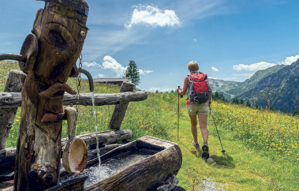
- Active & Green
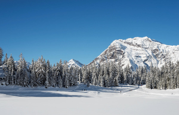
Snowshoeing in Valmalenco
Alpe Oro - Alpe Entova - Alpe Palù - Alpe Musella - Alpe Prabello - Lago di Chiesa
Turning to the Alpine Guides of Valmalenco is the best way to enjoy snow excursions with peace of mind. Amongst the many winter season offers, there are always planned guided moonlight tours with snowshoes, as well as fantastic springtime tours of Bernina (4050 m).
1) ALPE DELL'ORO 2010 m – BEFORE THE MAJESTIC MOUNT DISGRAZIA
Departure place: Chiareggio 1593 m
Ascent: 400 mt
Walking time (one way): 1,30 hrs
Easy route on a mule track. Departing from Chiareggio, follow the road leading to the Muretto Pass and that will take you to Alpe dell’Oro without difficulty.
This path is mostly beaten in Spring, when the road that links San Giuseppe to Chiareggio is open and the sun begins to shine over the valley.
The path gradually climbs through the fir wood until it reaches an elevation from which there is a wonderful sight of the Northern face of mount Disgrazia.
Bars and restaurants: in Chiareggio, open all year round.
2) ENTOVA 1926 m – LONELY ALPE ENTOVA
Departure place: San giuseppe 1500 m
Ascent: 426 m
Duration (one way): 1,30 hrs
Follow the road that starts at the parking of the Barchi chair lift and leads to Barchi-Lago Palù for 10 minutes, then turn on the left, heading Westwards, and take the path that crosses pristine pastures and woods until you reach Alpe Entova. Follow the signs to Bracciascia-Alpe Entova, on the way to the Longoni hut.
Bars and restaurants: at the departure place (S. Giuseppe)
3) THE MAGIC OF LAKE PALU' 2010 m
Departure place: San giuseppe 1500 m
Ascent: 510 m
Duration (one way): 1,30 hrs
Bars and restaurants: along the route – Barchi hut and or La Gusa restaurant, Palù hut. In the ski area there are several kiosks, Campanacci restaurant or Malga Rundai.
An easy itinerary that is perfect for families. The snow-clad path twists and turns up to Barchi and then through the woods. It isn’t difficult at all to orient oneself since the path is widely known and well-signaled. Those wanting to take an alternative and “lonelier” walk can reach Lake Palù passing through Paluetto and Barchetto. In this case the ascent is slightly steeper but fulfilling thanks to the amazing view of the pastures it crosses. We suggest a walk around the Lake (about 40 min); this is an easy trail on the shores of the lake from which there is an amazing sight of the surrounding mountains. The bravest may walk on the frozen - usually snow-clad - lake.
4) THE UNTAMED ALPE MUSELLA 2021 m
Departure place: Campo Franscia 1502 m
Ascent: 519 mt
Duration (one way): 2 hrs
This is a very interesting, quite easy route. Departing from Campo Franscia, cross the bridge and, once close to the Scerscen creek, take the path/mule track that ascends first to Alpe Foppa and from there follow the signs to Alpe Musella. It is possible to take an alternative return path: descend from Alpe Campascio and from there follow the wide path that reaches the departure point of the Campolungo chair lift. The path descends steeply along the huts in Dosso dei Vetti and in a little time reaches the highest part of Campo Franscia.
Bars and restaurants: hotel/restaurant Edelweiss in Campo Franscia
IMPORTANT: Alpe Musella can also be reached departing from Campo Moro. Park the car close to the first dam. Walk on the dam wall and follow a dirt road and after a while take the path on the right until reaching Alpe Musella. It is possible to go back to Campo Franscia by crossing Alpe Campascio.
5) AT THE FOOT OF PIZZO SCALINO - ALPE PRABELLO 2227 m
Departure place: Parking on the road to Campo Moro 1940 m
Ascent: 290 m
Duration (one way): 2 hrs
Bars and restaurants: Cà Runcasch hut, open all year round in Campagneda. Cristina hut open on Saturday and Sunday.
Classic route with several alternatives. The easiest route starts at the parking of the Cà Runcasch and Cristina mountain huts at about 1900 m. The road from Campo Franscia is usually snow-clad, therefore it’s necessary to travel with chains aboard or winter tires. Leaving the parking it’s easy to reach Campascio, where two paths depart:
- follow the signs on the right, direction South-East leading to the Cristina hut;
- follow the road, go by the Cà Runcasch hut and then keep on following the road that leads to the plateau of Prabello.
THE TOUR OF THE 3 HUTS – This is a great alternative to the previous route, but the car has to be left at the parking of the first dam. After a 5 minute walk you’ll reach the Zoia hut (open on weekends in winter). Follow the steep path along the cliffs used for climbing, where the wood gets sparser and sparser. Here there’s a hump from which there’s a wonderful view of Valmalenco and Pizzo Scalino. Walk another 45 minutes to reach Alpe Campagneda. Close to the agriturismo Il Cornetto, follow a small path that crosses the woods towards the Cristina hut/Alpe Prabello or head for the Cà Runcasch hut and then go towards Prabello. You can take the same route to go back to the departure point or choose to pass by the foot of Pizzo Scalino, direction North-East, until reaching the first lake of Campagneda, that freezes in winter. In a short time you’ll get back to Cà Runcasch and then to the Zoia hut.
6) AT THE FOOT OF PIZZO SCALINO - ALPE PRABELLO 2227 m
Departure point: Alpe Largone 1800 m
Ascent: 427 m
Duration of the whole loop route: 5 hrs
Bars and restaurants: Cristina hut, open on Saturday and Sunday. Close to the described route there is the Cà Runcasch hut, open all year round.
If you have good orientation skills you can carry out the ascent towards Alpe Largone inferiore, following a path through the woods. Park along the road to Campo Moro (about 1800 m) and go South-Westward towards Alpe Largone superiore and then Aquanegra. From here, go North-Eastward until reaching Alpe Prabello, where the Cristina hut is located. The way back passes by Sasso dell’Agnello. This is a rarely beaten and demanding route: the reason is not the ascent, but the strong orientation skills that it requires, in particular in the event of heavy snow, when it is hard to find traces of the path.
7) THERE ONCE WAS A LAKE – THE LAKE OF CHIESA 1614 m
Departure point: Chiesa in Valmalenco 1100 m
Ascent: 514 m
Duration (ascent only): 1,30 hrs
Duration of the Chiesa/Alpe Lago/Pirlo/Primolo loop: 4hrs
Bars and restaurants: in Primolo only
Among larches and pines towards the wonderful basin of Alpe Lago. The route begins at the first hairpin turn on the road to Primolo. Follow the snow-clad path that ascends through the larch wood and, by leaving on your right the path to Alpe Giumellino, you’ll reach Alpe Lago. You can take the same route to go back to Chiesa or, as an alternative, keep going Northward until Pirlo and then Primolo.
In Pirlo there is the interesting slimestone path that also leads to an ancient lathe. From Primolo, follow the path that in short time takes you to Gande, in Chiesa in Valmalenco. In case you want to follow this loop it is advisable to park the car in Gande in the morning. As an alternative, depart from Primolo and follow the road that goes back to the first hairpin turn.
Attachments
Cartina e descrizione degli itinerari di ciaspole in Valmalencocartina e descrizione degli itinerari di ciaspole a Caspoggio - Valmalenco


THE TRAILS IN CASPOGGIO
THE FOLLOWING TRAILS START FROM THE TOWN CENTRE.
BEFORE TAKING THOSE TRAILS, MAKE SURE THAT SNOW IS SUFFICIENT.
TRAIL NR. 1
TRAIL FOR BEGINNERS
- Elevation gain: 110 m
- Time: 40'
- Departure point: Zenith sports centre (Caspoggio)
- Arrival point: Santa Elisabetta
- Description: This simple route follows the mule which runs along the sports centre and leads to the village of Santa Elisabetta. It is possible to return on the same track or on the trail nr. 2, described hereunder.
TRAIL NR. 2 - TRAIL AMONGST THE VALLEYS
EASY TRAIL SUITABLE FOR ADULTS AND CHILDREN
- Elevation gain: 110 m
- Time: 50 min
- Departure point: località Bràcia
- Arrival point: Musni di Santa Elisabetta.
- Description: This route is the continuation of the trail nr. 1. Once in Santa Elisabetta - close to the Alpacas La Foppa farm - follow a panoramic trail which runs below the Caspoggio - Sant'Antonio chairlift, and quickly reaches the settlement named Bràcia di Caspoggio. From here, follow the road that leads to the centre of Caspoggio. It is also possible to follow the trail the other way around,so departing from the town centre and heading for Bràcia. Once in Santa Elisabetta it is possible to descend in Caspoggio and then follow - using your intuition - the former ski slope until reaching Restaurant Colombo or the departing point of the chairlift.
TRAIL NR. 3 - A TOUR ACROSS THE MEADOWS
- Elevation gain: 180' ca
- Time: 2 hrs
- Departure point: Bràcia
- Itinerary: Cüràda, Astù, S. Antonio, Prabello
- Arrival point: Santa Elisabetta.
- Description: This trail offers a wonderful panoramic view and is easily reached. Departing from the centre of Caspoggio, go up to the highest part of the town (Bràcia) by following a road or the tiny paths that link the settlements of Caspoggio.
Along this trail there is the "truna of Caspoggio", a tunnel surrounded by ancient buildings, which is a true historic and cultural peculiarity of the town.
Continue along a snow-clad road until reaching Curada, with its lovely homes that perfectly fit in the surrounding landscape and that overlook the town. The next stage is Sant'Antonio, marked out by the white church overlooking the pasture. From there, a detour takes to Astù: the settlement is located 150m higher than Curada, but is almost completely hidden by the high firs and larches that give shade to the magical clearing. The are two options for the way back from Sant'Antonio: follow the road that crosses Prabello and Santa Elisabetta . From there, follow either the trail nr. 1 or nr.2.
TRAIL NR. 4 - THE CATTLE TRAIL
LOOP TRAIL AT AN HIGHER ELEVATION, A GOOD TRAINING IS NECESSARY
- Elevation gain: 270 m from Sant'Antonio to La Ferla
- Time: 2 hrs from Sant'Antonio to La Ferla and return
- Description: See trail nr.3, which leads to Sant'Antonio. This is the departure point of the old trail known as "the cattle trail", that is now a road used by ski mountaineers and which leads to La Ferla. Return along the former ski slope or the road that departs from Ferlo, crosses Ces Musin and then reaches Motta. From there, it is possible to return to Sant'Antonio along the "Milk trail".
TRAIL NR. 5
- Elevation gain: 700 m from Sant'Antonio to Dosso dei Galli
- Time: 2.30 hrs
- Description: The suggested itinerary is suitable for well-trained snowhoers. Departing from Sant'Antonio, follow the milk trail and reach Motta (in about 30'). Then cross Cès Musìn and head for the panoramic ledge (about 30'). If you can withstand the effort and if you enjoy steep ascents, you have the chance to continue until Dosso dei Galli, the former arrival point of the ski facilities. (1.20 hrs)
TRAIL NR. 5/A
NICE ALTERNATIVE TO TRAIL NR. 5
- Time: 1 hr
- Description: Depart from Motta and cross Cès Musìn, then head for the Valle di Dagua by following a path that climbs gently up the mountain across snow-clad firs and reaches the panoramic ledge of Piazzo Cavalli, close to the Chapel of the Alpine troops.